The Votes Are In!
2024 Readers' Choice is back, bigger and better than ever!

 View Winners →

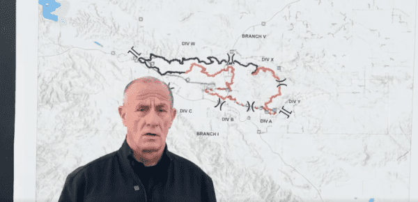
A wildfire in Aguanga that has charred 2,487 acres near the junction of Highways 79 and 317 was 70% contained with full containment expected by Monday, the Riverside County Fire Department reported Saturday.
The fire started at about 12:40 p.m. Monday in the area of Highlands and Aguanga Ranchos roads. The blaze started near a residence, but the exact cause was under investigation.
“Fire behavior was minimal overnight, with no fire growth. Firefighters worked through the evening to cool hot spots and address nuisance smokes in the burn area,” the fire agency said in a statement Saturday.
“Steep and rugged terrain remains a challenge, and the weather will be warm and drive through Saturday,” according to the statement. “Firefighters will continue building containment line around the fire perimeter today while cooling smoldering material.”
Evacuation orders remained at the perimeter of the Highland Fire, leaving the rest of the impacted area under an ongoing evacuation warning, which means residents can stay in their homes but should remain alert.
The warning area is located north of the San Diego/Riverside County line, south of Cottonwood School Road, east of Crosley Truck Trail and west of Sorenson Road.
A reception and care center was set up at Great Oak High School at 32555 Deer Hollow Way in Temecula. An animal evacuation center for large and small animals was set up at the San Jacinto Animal Campus at 581 South Grand Ave. in San Jacinto.
Two firefighters were injured battling the blaze.
Thirteen structures were destroyed by the fire, with another seven damaged.
GoFundMe accounts were established for those who suffered property losses. They are at the following links:
A searchable map of the evacuation area was available at www.linktr.ee/calfirerru.
Road closures were for:
The cause of the fire is under investigation.
We are able to provide high-quality political journalism to you for free thanks to our advertisers. So that you can continue to enjoy HEYSOCAL's in-depth reporting, we ask that you please turn off your ad blocker and come on in, free of charge.
Subscribe to our newsletter for this giveaway and many more. Also, stay in the loop for SoCal news and updates.
Your subscription has been confirmed. You've been added to our list and will hear from us soon.
Your request has been confirmed! We will get in touch with you shortly.